📰 Latest Update (23 May 2026): VB-G RAM G के 8 Draft Rules publish हुए। [VB-G RAM G Draft Rules 2026 — पूरी जानकारी]
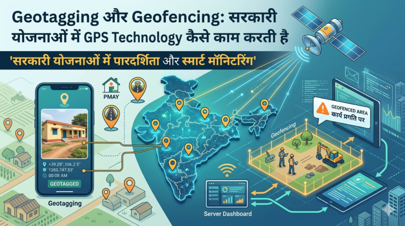
क्या आप जानते हैं? जब भी VB-G RAM G के तहत कोई तालाब बनता है, PMAY-G में घर बनता है, या MGNREGA के तहत सड़क बनती है — तो उस काम की GPS location, फोटो और progress एक satellite system पर real-time में record होती है। यही है Geotagging।
और जब Face Authentication से attendance लेते समय system automatically check करता है कि “यह व्यक्ति actually उसी काम की जगह पर है या नहीं” — तो यही है Geofencing।
MGNREGA में geotagging of assets 526% बढ़ी 2014 से 2025 के बीच — यही technology भ्रष्टाचार रोकने का सबसे बड़ा हथियार बनी।
Rajasthan के CM भजन लाल शर्मा ने कहा — VB-G RAM G में geo-tagging, satellite imagery, mobile apps और AI से transparency सुनिश्चित होगी और हर 6 महीने में digital evidence के साथ social audit होगी।
VB-G RAM G Act 2025 में real-time digital tracking, geotagged assets और Direct Benefit Transfer शामिल हैं।
इस लेख में जानें — Geotagging और Geofencing क्या है, सरकारी योजनाओं में कैसे use होती है, VB-G RAM G और MGNREGA में क्या role है, ISRO और NREGASoft से connection, आम नागरिकों को क्या फायदा, और UPSC के लिए key points।
Table of Contents
📊 एक नज़र में
| विवरण | Geotagging | Geofencing |
|---|---|---|
| हिंदी नाम | भू-अंकन / जियोटैगिंग | भू-बाड़ / जियोफेंसिंग |
| क्या है? | GPS location + photo record | Virtual boundary बनाना |
| क्या करता है? | Asset की location document | Location-based alert/restriction |
| Technology | GPS + Camera + Internet | GPS + Radius + Software |
| MGNREGA में | Assets geo-tag करना | Attendance verification |
| VB-G RAM G में | हर काम का record | Worksite boundary verify |
| Tool | NRSC Mobile App, Bhuvan | NMMS App |
| ISRO connection | ISRO satellite verify करती है | – |
| भ्रष्टाचार पर असर | फर्जी asset नहीं दिखा सकते | Proxy attendance नहीं होगी |
🗺️ Geotagging (जियोटैगिंग) क्या है?
Geotagging का मतलब है किसी physical asset या कार्य को उसकी GPS location (latitude/longitude) के साथ digitally tag करना और उस location पर एक real photo attach करना।
सरल उदाहरण
अगर VB-G RAM G के तहत आपके गांव में एक check dam बना:
पहले (MGNREGA era में): कागज़ पर लिखा जाता था — “गांव XYZ में check dam बना, ₹5 लाख खर्च।” कोई proof नहीं। कभी-कभी काम हुआ ही नहीं होता था।
अब (Geotagging के साथ):
- काम शुरू होने से पहले Before photo — GPS location के साथ
- काम के दौरान During photo — progress दिखाती है
- काम पूरा होने पर After photo — final asset की photo
- हर photo में date, time, latitude, longitude automatically embed
- ISRO satellite से independent verification — actual ground पर है या नहीं
Geotagging में क्या record होता है?
| Data Point | विवरण |
|---|---|
| Latitude | 28.6139° N (example) |
| Longitude | 77.2090° E (example) |
| Accuracy | ±3 meters (GPS) |
| Timestamp | Date + Time + Time Zone |
| Photo | Before/During/After |
| Work ID | Unique identifier |
| Gram Panchayat | जिला/ब्लॉक/GP code |
| Worker details | किसने tag किया |
🔵 Geofencing (जियोफेंसिंग) क्या है?
Geofencing एक virtual boundary है जो किसी physical location के आस-पास GPS coordinates से define की जाती है।
सरल उदाहरण
VB-G RAM G worksite पर:
- Worksite की GPS location: 28.6139° N, 77.2090° E
- Geofence radius: 500 meters
- अब system यह जानता है कि “worksite से 500 meter के दायरे को geofence कहेंगे”
जब कोई मज़दूर Face Authentication से attendance देता है:
- System उसका current GPS location check करता है
- अगर वह geofence के अंदर है → attendance accept ✅
- अगर वह geofence के बाहर है → attendance reject ❌ (alert जाता है)
Geofencing से क्या रुकता है?
| समस्या | Geofencing का समाधान |
|---|---|
| Proxy attendance | दूसरे की तरफ से कोई और attendance नहीं दे सकता |
| Ghost workers | जो काम पर नहीं है, attendance नहीं |
| Fake muster roll | Actual location verify होती है |
| Late/early marking | Timestamp + location दोनों |
| Multiple sites fraud | एक व्यक्ति एक समय पर एक ही site पर |
🏗️ VB-G RAM G में Geotagging और Geofencing
PIB Backgrounder (11 मई 2026) में स्पष्ट उल्लेख है:
“Technology-enabled governance through biometric authentication, geo-referencing, digital monitoring, and time-bound wage payments aims to strengthen transparency and accountability.”
और:
“Geo-tagging of assets, real-time dashboards, mobile-based monitoring and strengthened social audits to ensure transparency, community participation and effective public oversight.”
VB-G RAM G में Geotagging का उपयोग
318 प्रकार के कार्यों में से हर एक के लिए:
- Before Geo-tagged Photo: काम शुरू होने से पहले
- Location confirmed — काम actually वहाँ होगा जहाँ कहा
- Yuktdhara पर map पर pin
- During Geo-tagged Photos: Progress tracking
- ISRO satellite से cross-verify
- Real-time dashboard update
- After Geo-tagged Photo: Completion
- Asset actually बना — ISRO independent verify
- Social audit में evidence
VB-G RAM G में Geofencing का उपयोग
Face Authentication attendance में geofencing का direct role:
- हर worksite की geofence define होती है
- Face scan → GPS check → अगर worksite पर है → attendance ✅
- Offline mode में भी data save होता है (sync बाद में)
- Exception mechanism: network नहीं तो alternate process
📉 MGNREGA में Geotagging का प्रभाव
MGNREGA में 2014 से 2025 के बीच geotagging of assets में 526% की extraordinary वृद्धि हुई — जिससे assets को spatial technology के माध्यम से verify और accountable किया जा सका।
इसका मतलब
2014 में: 100 assets में से शायद 15-20 ही geo-tagged थे 2025 में: 100 में से 95+ geo-tagged
परिणाम:
- Fake assets की संख्या में भारी कमी
- 99.9-100% digital payments — Aadhaar-based payment system से wage disbursements में leakages eliminate
- महिलाओं की भागीदारी 48% से 58.15% (2013-14 से 2025-26) — real work, real attendance
🛰️ ISRO और Geotagging का Connection
युक्तधारा और ISRO की Bhuvan platform में geotagging का triple verification होता है:
Level 1: Mobile App Geotagging
- Field worker mobile app से photo लेता है
- GPS automatically capture होती है
- NREGASoft/VB-NRIS पर upload
Level 2: Satellite Cross-verification
- ISRO के IRS satellite से 3 meter resolution में photo
- Yuktdhara पर field photo और satellite image compare
- Discrepancy होने पर automatic flag
Level 3: AI Analytics
- Pattern recognition — क्या asset वाकई बना?
- Historical comparison — उसी location पर पहले क्या था?
- Anomaly detection — suspicious cases alert
📱 कौन-कौन से Apps Use होते हैं?
1. NMMS App (National Mobile Monitoring System)
- VB-G RAM G / MGNREGA attendance के लिए
- Face Authentication + GPS location
- Geofenced attendance verification
- Offline mode available
- Real-time muster roll
2. NRSC Mobile Apps (ISRO)
NRSC ने कई scheme-specific geotagging apps बनाए हैं:
- Bhuvan-MGNREGA app: Assets track करना
- PMAY-G app: घर निर्माण monitoring
- RKVY app: कृषि assets geotagging
- Watershed app: Watershed structures
3. Yuktdhara Portal
- Gram Panchayat level planning में geotagging
- Satellite imagery के साथ comparison
- Block-level approval workflow
4. NREGASoft
- MGNREGA का central MIS
- Geotagged data automatically ingest
- Reports और dashboards
🏛️ अन्य सरकारी योजनाओं में Geotagging
Geotagging केवल VB-G RAM G/MGNREGA में नहीं — लगभग सभी बड़ी सरकारी योजनाओं में use होती है:
PM Awas Yojana (PMAY-G)
- हर घर के निर्माण की 4 stages geo-tagged
- Stage 1: Foundation, Stage 2: Lintel, Stage 3: Roof, Stage 4: Completion
- Photo के बिना अगली installment नहीं
PM Gati Shakti
- सभी infrastructure projects की GIS mapping
- 1,600+ data layers — सब geo-referenced
- Real-time progress tracking
Jal Jeevan Mission (JJM)
- हर गांव में water supply infrastructure geo-tagged
- Pipeline, tank, tap — सब GPS mapped
PM Surya Ghar Yojana
- Solar panel installation की geo-tagged photo
- DISCOM verification के लिए
- Subsidy approval में mandatory
Farmer Registry (Agristack)
- खसरा/भूमि का geo-referenced record
- Satellite से crop verification
- Insurance claims में use
PMKVY (Skill Development)
- Training centers की geo-tagged location
- Biometric attendance (face/fingerprint)
- Fake training centers detect
🆚 Geotagging vs Geofencing — मुख्य अंतर
| पहलू | Geotagging | Geofencing |
|---|---|---|
| उद्देश्य | “यह काम यहाँ हुआ” document करना | “यह व्यक्ति यहाँ है” verify करना |
| कब use | Asset creation/monitoring | Attendance/Access control |
| Data type | Location + Photo + Timestamp | Virtual boundary + Alert |
| Permanent? | हाँ — permanent record | नहीं — temporary boundary |
| Examples | Check dam, Road, Well | Worksite attendance |
| Verifiable by | ISRO satellite | GPS check |
| Anti-fraud use | फर्जी asset नहीं दिखा सकते | Proxy attendance नहीं होगी |
| VB-G RAM G role | All 318 works document | Face authentication verify |
💡 Geo-referencing क्या है?
PIB में एक तीसरा term भी आता है — Geo-referencing:
Geo-referencing = किसी digital map या satellite image को real-world GPS coordinates से align करना।
यानी:
- Yuktdhara में जो satellite image दिखती है — उसे actual GPS coordinates से align किया गया है
- इसीलिए map पर जो point click करते हैं, उसकी actual ground location accurate निकलती है
- VB-G RAM G की VGPP planning में यह fundamental है
| Term | सरल अर्थ |
|---|---|
| Geotagging | GPS + Photo attach करना |
| Geofencing | Virtual boundary बनाना |
| Geo-referencing | Map को GPS से align करना |
| Geo-coding | Address को GPS coordinates में convert |
⚠️ Geotagging की चुनौतियां
1. Internet Connectivity
ग्रामीण क्षेत्रों में poor connectivity → real-time upload मुश्किल। समाधान: Offline mode — later sync।
2. GPS Accuracy
Dense forest या tall buildings में GPS drift हो सकती है। समाधान: Multiple readings, ISRO satellite cross-check।
3. Photo Manipulation
कुछ लोग पुरानी photos upload करते हैं। समाधान: Timestamp metadata verify, AI image analysis।
4. Device Availability
सभी field workers के पास smartphone नहीं। समाधान: Shared devices, CSC center support।
5. Training Gap
Officials को proper training नहीं। समाधान: VB-G RAM G में 9% administrative budget — training के लिए।
🌟 भविष्य में क्या होगा?
AI + Geotagging = Game Changer
2026 के बाद VB-G RAM G में AI analytics:
- Satellite image से automatic asset quality assessment
- “Check dam की height सही है?” — AI verify करेगा
- Predictive maintenance — कब repair होगी?
Drone Geotagging
- PMKVY में Drone Pilot course है
- Government drone fleet से geotagging
- Remote/inaccessible areas में भी coverage
Blockchain + Geotagging
- Immutable record — कोई change नहीं कर सकता
- Audit trail permanent
📞 आधिकारिक स्रोत
- NREGASoft: nreganet.nic.in
- NMMS App: Google Play Store
- Yuktdhara: bhuvan-app2.nrsc.gov.in
- NRSC Mobile Apps: bhuvanmaps.nrsc.gov.in
- VB-G RAM G: rural.gov.in
- PIB: pib.gov.in
🔗 संबंधित लेख
- VB-G RAM G अधिनियम 2026
- युक्तधारा पोर्टल 2026
- VB-G RAM G और PM Gati Shakti
- VB-G RAM G 318 कार्य
- VB-G RAM G vs MGNREGA
- PM Gati Shakti योजना
अक्सर पूछे जाने वाले प्रश्न (FAQ)
Geotagging क्या है और यह कैसे काम करती है?
Geotagging किसी physical asset या काम को उसकी GPS location (latitude/longitude) और real photo के साथ digitally document करने की प्रक्रिया है। VB-G RAM G में जब कोई तालाब, सड़क या check dam बनता है तो उसकी Before/During/After photos GPS coordinates के साथ NREGASoft पर upload होती हैं। ISRO satellite independently verify करती है कि काम actually हुआ या नहीं। MGNREGA में 2014 से 2025 के बीच geotagging में 526% की extraordinary वृद्धि हुई।
Geofencing क्या है?
Geofencing एक virtual GPS boundary है जो किसी physical location के आस-पास define की जाती है। VB-G RAM G worksite पर जब कोई मज़दूर Face Authentication से attendance देता है, तो system automatically check करता है कि वह worksite की geofence के अंदर है या नहीं। Geofence के अंदर = attendance accept। Geofence के बाहर = attendance reject। इससे proxy attendance और ghost workers की समस्या खत्म होती है।
VB-G RAM G में Geotagging का क्या महत्व है?
VB-G RAM G Act 2025 में real-time digital tracking, geotagged assets और Direct Benefit Transfer शामिल हैं। CM भजन लाल शर्मा के अनुसार VB-G RAM G में geo-tagging, satellite imagery, mobile apps और AI से transparency सुनिश्चित होगी और हर 6 महीने में digital evidence के साथ mandatory social audit होगी। इससे फर्जी assets दिखाना impossible हो जाता है।
ISRO का Geotagging से क्या संबंध है?
ISRO की Bhuvan platform और NRSC के IRS satellites गोटैगिंग के तीन levels में काम करते हैं: (1) NRSC mobile apps से field-level geotagging (2) Yuktdhara portal पर satellite imagery से field photos की cross-verification (3) AI analytics से anomaly detection। ISRO satellites 3 meter resolution में independent verification करती हैं कि reported location पर actually वह काम हुआ या नहीं।
NMMS App में Geotagging और Geofencing कैसे काम करती है?
NMMS (National Mobile Monitoring System) App VB-G RAM G/MGNREGA attendance के लिए है। इसमें: (1) Face Authentication — biometric verification (2) GPS location capture — worksite पर है या नहीं (Geofencing) (3) Real-time NREGASoft पर data upload (4) Muster roll automatically update (5) Offline mode — network नहीं हो तो बाद में sync। Exception handling mechanism available है genuine network issues के लिए।
Geotagging और Geofencing में क्या अंतर है?
Geotagging एक document करने का tool है — “यह asset इस GPS location पर बना, इसका photo यह है।” यह permanent record है। Geofencing एक verification tool है — “यह व्यक्ति अभी इस virtual boundary के अंदर है या नहीं।” यह real-time check है। Geotagging assets के लिए, Geofencing attendance/access के लिए। दोनों मिलकर VB-G RAM G में भ्रष्टाचार रोकने का strongest technical mechanism बनाते हैं।
PM Gati Shakti में Geotagging कैसे use होती है?
PM Gati Shakti GIS Platform में 1,600+ data layers सभी geo-referenced हैं। VB-G RAM G के सभी 318 कार्य Yuktdhara → VB-NRIS → PM Gati Shakti chain में geo-tagged होते हैं। ISRO satellite real-time progress track करती है। AI-enabled analytics से anomalies detect होती हैं। Real-time dashboards पर Central से Gram Panchayat तक सब visibility।
PMAY-G में Geotagging कैसे काम करती है?
PMAY-G (प्रधानमंत्री आवास योजना ग्रामीण) में हर घर निर्माण की 4 stages geo-tagged होती हैं: Foundation, Lintel, Roof, Completion। NRSC का PMAY-G mobile app से beneficiary घर की geo-tagged photo upload करता है — GPS coordinates के साथ। बिना geo-tagged photo के अगली installment नहीं मिलती। ISRO satellite से aerial verification भी होती है। VB-G RAM G में PMAY-G works (90/95 person-days) के लिए भी यही process।
Geo-referencing, Geotagging और Geofencing में क्या अंतर है?
तीनों अलग-अलग concepts हैं: Geotagging = किसी photo/asset को GPS location attach करना (permanent record)। Geofencing = virtual GPS boundary बनाना (real-time location check)। Geo-referencing = digital map/satellite image को actual GPS coordinates से align करना (Yuktdhara में use)। तीनों मिलकर VB-G RAM G, PM Gati Shakti और युक्तधारा की GIS ecosystem बनाते हैं।
Geotagging UPSC के लिए क्यों important है?
Geotagging UPSC Prelims और Mains दोनों के लिए important है: Prelims — Science & Technology, Rural Development current affairs। Mains GS-3 — Technology for governance, Anti-corruption measures, Rural employment। Key facts: MGNREGA में 526% geotagging increase, VB-G RAM G में real-time geotagged assets, ISRO-NRSC connection, Yuktdhara platform, NMMS App, Face Authentication + Geofencing। यह “Technology for Good Governance” का best example है।
डिसक्लेमर
यह लेख PIB, ISRO/NRSC, ग्रामीण विकास मंत्रालय और आधिकारिक सरकारी sources पर आधारित है। नवीनतम जानकारी के लिए rural.gov.in और bhuvan.nrsc.gov.in देखें।
लेखक: सरिता मिश्रा — सरिता “सरकारी योजना” की मुख्य लेखिका हैं। वे केंद्र और राज्य सरकार की योजनाओं पर शोध करके उन्हें आसान हिंदी में समझाती हैं, ताकि हर आम परिवार ज़रूरी जानकारी आसानी से समझ सके। हर लेख आधिकारिक स्रोतों (PIB, मंत्रालय की वेबसाइट और सरकारी पोर्टल) से जाँचने के बाद ही प्रकाशित किया जाता है।